


คำอธิบายของ GPS Fields Area Measure
Easy to use, useful app for an area, distance and perimeter management.
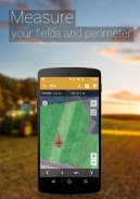
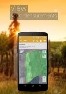
This tool is helping for million people to measure their fields, mark their needed points and sharing their measured maps with their colleagues.
Don't waste your time searching for the best free app to measure area, distance and perimeter - choose our app and simplify the measuring process!
UNIQUE FEATURES:
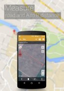
➜ Fast area/distance marking
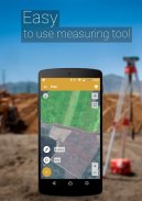
➜ Smart Marker Mode for very accurate pin placement
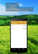
➜ Name, save, group and edit measurements
➜ “Undo” button for all actions
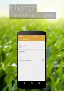
➜ GPS tracking/Auto measure for walking/driving around specific boundaries
It also includes a feature to send an auto-generated link to your friends or partners of pinned/selected area, direction or route – displays the area you want to share.
A feature to add the point of interest or POI on the field helps to avoid stones, mark fences or boundaries of paddocks, graze territories for dairy cows, cattle, beef and other livestock.
In need for more advanced versions?:
❖ PRO version
https://goo.gl/Gh5Jp6
❖ Ad-free version
https://goo.gl/S0u7f1
Try out our other apps for farmers:
❖ Field Navigator
https://goo.gl/hZBnJI
❖ AgroBASE
https://goo.gl/1v0bFt
❖ Soil Sampler
https://goo.gl/6vHwrF
❖ Commodity Spy
https://goo.gl/1f72jm
❖ Calcagro
https://goo.gl/a1jKeM
Disclaimer: Subscription is not included in ad-free or PRO versions, it is an additional feature obtained by an in-app purchase. The mentioned versions influence and expand functionality.
* The app perfectly works with a GARMIN GLO and GARMIN GLO 2 external GPS antennas.
Download it and start measuring your fields today!
GPS Field Area Measure is also useful as a map measurement tool for outdoor activities, range finder applications and sports such as biking or marathon. Comes in handy when exploring golf area or as a golf distance meter, convenient for land surveys, practical for field pasture area measure, helpful in garden and farm work or planning, great to keep area records. It’s great for constructions and agricultural fencing. This application is practical even for solar panel installation, roof area estimation or trip planning.
Our measuring app has the highest accuracy in the market, that being the main reason why we’re the leading measuring app among construction sites, building and farm contractors and farmers.
Among our users are people constructing roofs, buildings and roads, farm owners who are spraying, fertilizing, seeding, harvesting farms or tilling. It’s helpful for biking, traveling or planning trips. For growing gardens and paddock, grass or lawn – we are the number one choice.
Including people who are farming beef, pork, or poultry – the application comes in handy for fence measuring and planning. Pilots can also use this app while flying in the fields. Farm managers and contractors who are exploiting agricultural work for farmers can use this app to count the amount of planted fields and share them with the owner. The fields are displayed in Google Maps.
It's a great tool for paddock calculation and measuring.
This is the best solution for farm owners who grow wheat, corn, rapeseed, maize, sugar beet and need to measure the planted area annually.
All in all, it is useful for:
- Farmers, for farm management
- Agronomists
- Town planners
- Construction surveyor
- Landscape artists
- Land based surveys
- Land record management
- Construction surveys
- Health, Education and facilities mapping
- Farm fencing
- Sports track measurement
- Construction sites and building sites area
- Asset mapping
- Landscape design
- GIS, ArcGIS, ArcMap
แอพที่มีประโยชน์และใช้งานง่ายสำหรับการจัดการพื้นที่ระยะทางและปริมณฑล
เครื่องมือนี้ช่วยให้ผู้คนนับล้านวัดสนามทำเครื่องหมายจุดที่ต้องการและแบ่งปันแผนที่ที่วัดได้กับเพื่อนร่วมงาน
อย่าเสียเวลาค้นหาแอพฟรีที่ดีที่สุดในการวัดพื้นที่ระยะทางและปริมณฑล - เลือกแอพของเราและทำให้กระบวนการวัดง่ายขึ้น!
คุณสมบัติที่ไม่ซ้ำกัน:
marking การทำเครื่องหมายพื้นที่ / ระยะทางที่รวดเร็ว
Marker Smart Marker Mode เพื่อการวางพินที่แม่นยำมาก
➜ชื่อบันทึกจัดกลุ่มและแก้ไขการวัด
➜ปุ่ม“ เลิกทำ” สำหรับทุกการกระทำ
➜การติดตามด้วย GPS / การวัดอัตโนมัติสำหรับการเดิน / ขับรถตามขอบเขตที่กำหนด
นอกจากนี้ยังมีคุณสมบัติในการส่งลิงค์ที่สร้างขึ้นอัตโนมัติไปยังเพื่อนหรือคู่ค้าของคุณในพื้นที่ที่ถูกตรึง / เลือกทิศทางหรือเส้นทาง - แสดงพื้นที่ที่คุณต้องการแชร์
คุณสมบัติในการเพิ่มจุดสนใจหรือจุดที่น่าสนใจบนสนามช่วยหลีกเลี่ยงหินทำเครื่องหมายรั้วหรือขอบเขตของม้างดินแดนกินหญ้าสำหรับโคนมโคเนื้อวัวและปศุสัตว์อื่น ๆ
ต้องการรุ่นที่สูงขึ้นหรือไม่:
❖รุ่น PRO
https://goo.gl/Gh5Jp6
version รุ่นที่ไม่มีโฆษณา
https://goo.gl/S0u7f1
ลองใช้แอพอื่น ๆ ของเราสำหรับเกษตรกร:
Navigator Field Navigator
https://goo.gl/hZBnJI
❖ AgroBASE
https://goo.gl/1v0bFt
Sam Soil Sampler
https://goo.gl/6vHwrF
Spy สินค้าโภคภัณฑ์ Spy
https://goo.gl/1f72jm
❖ Calcagro
https://goo.gl/a1jKeM
ข้อจำกัดความรับผิดชอบ: การสมัครสมาชิกไม่รวมอยู่ในโฆษณาฟรีหรือรุ่น PRO มันเป็นคุณสมบัติเพิ่มเติมที่ได้รับจากการซื้อในแอป รุ่นที่กล่าวถึงมีอิทธิพลและขยายการทำงาน
* แอปทำงานได้อย่างสมบูรณ์แบบกับเสาอากาศภายนอก GPS GLO และ GARMIN GLO 2
ดาวน์โหลดและเริ่มต้นการวัดสาขาของคุณวันนี้!
การวัดพื้นที่ GPS ยังมีประโยชน์ในฐานะเครื่องมือวัดแผนที่สำหรับกิจกรรมกลางแจ้งแอพพลิเคชั่นตัวค้นหาระยะไกลและกีฬาเช่นการขี่จักรยานหรือการวิ่งมาราธอน มีประโยชน์เมื่อสำรวจพื้นที่เล่นกอล์ฟหรือเป็นมาตรวัดระยะทางกอล์ฟสะดวกสำหรับการสำรวจที่ดินปฏิบัติจริงสำหรับการวัดพื้นที่ทุ่งหญ้าเป็นประโยชน์ในงานสวนและฟาร์มหรือการวางแผนที่ดีในการเก็บบันทึกพื้นที่ เหมาะอย่างยิ่งสำหรับการก่อสร้างและการฟันดาบทางการเกษตร แอปพลิเคชั่นนี้ใช้งานได้จริงสำหรับการติดตั้งแผงเซลล์แสงอาทิตย์การประมาณพื้นที่หลังคาหรือการวางแผนการเดินทาง
แอปวัดของเรามีความแม่นยำสูงสุดในตลาดนั่นคือเหตุผลหลักว่าทำไมเราจึงเป็นแอปวัดชั้นนำในสถานที่ก่อสร้างผู้สร้างและผู้รับเหมาฟาร์มและเกษตรกร
ในหมู่ผู้ใช้ของเราคือคนที่สร้างหลังคาอาคารและถนนเจ้าของฟาร์มที่พ่นพ่นใส่ปุ๋ยเพาะเมล็ดเก็บเกี่ยวพืชผลหรือไถพรวน การขี่จักรยานการเดินทางหรือการวางแผนการเดินทางมีประโยชน์ สำหรับการปลูกในสวนและคอกข้างสนามหญ้าหรือสนามหญ้า - เราเป็นตัวเลือกอันดับหนึ่ง
รวมถึงคนที่กำลังเลี้ยงเนื้อวัวเนื้อหมูหรือสัตว์ปีกแอปพลิเคชันมีประโยชน์สำหรับการวัดและวางแผนรั้ว นักบินสามารถใช้แอพนี้ในขณะที่บินอยู่ในทุ่ง ผู้จัดการฟาร์มและผู้รับเหมาที่ใช้ประโยชน์จากงานเกษตรกรรมให้กับเกษตรกรสามารถใช้แอพนี้เพื่อนับจำนวนของพื้นที่เพาะปลูกและแบ่งปันกับเจ้าของ ฟิลด์จะปรากฏใน Google Maps
มันเป็นเครื่องมือที่ยอดเยี่ยมสำหรับการคำนวณและการวัดคอก
นี่คือทางออกที่ดีที่สุดสำหรับเจ้าของฟาร์มที่ปลูกข้าวสาลีข้าวโพดเรพซีดข้าวโพดบีทรูทและต้องการวัดพื้นที่เพาะปลูกเป็นประจำทุกปี
สรุปแล้วมันมีประโยชน์สำหรับ:
- เกษตรกรเพื่อการจัดการฟาร์ม
- นักปฐพีวิทยา
- นักวางผังเมือง
- ช่างก่อสร้าง
- ศิลปินแนวนอน
- การสำรวจที่ดิน
- การจัดการบันทึกที่ดิน
- การสำรวจการก่อสร้าง
- แผนที่สุขภาพการศึกษาและสิ่งอำนวยความสะดวก
- ฟันดาบฟาร์ม
- วัดสนามกีฬา
- พื้นที่ก่อสร้างและพื้นที่ก่อสร้าง
- การทำแผนที่สินทรัพย์
- การออกแบบภูมิทัศน์
- GIS, ArcGIS, ArcMap
GPS Fields Area Measure--เวอร์ชั่น3.14.5
(04-03-2024)
GPS Fields Area Measure - ข้อมูล APK
เวอร์ชั่น APK: 3.14.5แพ็คเกจ: lt.noframe.fieldsareameasureแอปในประเภทเดียวกัน
คุณอาจจะชอบ...


